Offline maps and places
Maps without signal
Tracking works without signal, but the map behind your route has to be on your phone already if you want to see it where there's none. There are two ways to save it. Offline map, under TOOLS on the Record map, picks the area for your trip. Settings › Offline Maps lets you choose an area yourself. Both keep the same saved maps.
Offline map, under TOOLS
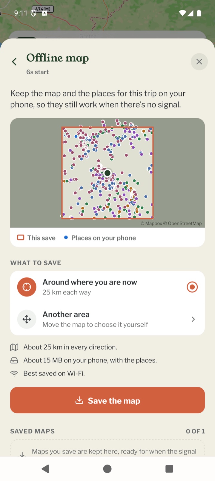
Open TOOLS and tap Offline map. A small map shows the area that will be saved, any maps you've saved already, and the places on your phone. Under What to save, pick one:
- Your route ahead: if this chapter has a route you've loaded, the next stretch of it with a margin either side. How far depends on how you're travelling, up to about 60 km on foot or 200 km by bike
- Around where you are now: about 25 km each way on foot, 50 km by bike
- Another area: move and zoom the map until the box covers what you want, then tap Save this area
Saving it
It says roughly how much room the map takes on your phone (around you on foot is usually about 15 MB) and that it's best saved on Wi-Fi. Tap Save the map. You can close the sheet while it saves, as long as Pebbls stays open. For a big area the closest zoom is left out to keep the size down. The places for the same area are saved along with the map, so its row says Map and places. If they didn't save, the ⋯ beside the map has Add the places.
Choosing an area in Settings
- Open Settings › Offline Maps and tap Add New Region
- Move the map so the square covers the area you want, then tap Looks good?
- Give the region a name, e.g. "North Cascades"
- Tap Download Region. Regions are usually 15 to 100 MB, so use Wi-Fi
How many maps
Day Trippers can keep 1 saved map and Explorer members can keep 4, counting the ones saved under TOOLS and in Settings together. Only one map saves at a time. Phones that had Pebbls before November 2026 may also list Global (Low Resolution), a rough world map the app used to save by itself. It doesn't count towards your maps, and the app no longer downloads it.
Deleting maps
Under TOOLS, tap the ⋯ beside a saved map and choose Delete this map. In Settings, open a region to delete it. Delete All Regions and Clear Map Cache are at the bottom of the Settings screen. If the map style changes, the screen offers Update All so your saved regions match.
Places you'll need
Places you'll need, under TOOLS, keeps drinking water, food shops, cafés, campsites, toilets, chemists, cash machines, bike shops and more on your phone, around you and along your route ahead. Pick what to look for (the kinds that suit how you're travelling are ticked to start with) and tap Download places for this trip. It needs signal. Without a loaded route it looks around where you are. Downloading places is free for everyone.
Using the places
They're listed nearest first, or in order along the route, with how far away or how far off the route each is, and opening hours where they're known. Tap one for directions in your maps app. Turn on On the map to show them on the Record map, and choose which kinds appear there. The ⋯ menu has Update now, Change what to download and Delete from this phone. The places come from OpenStreetMap, where some small shops are missing, so ring ahead before you rely on one.
Keeping places up to date
With Explorer, Keep places up to date as I travel is on to start with. Once you've moved on about 7 km on foot or 25 km by bike, Pebbls quietly downloads the places around you and along the route ahead and adds them to the ones you have, dropping those far behind you. It never downloads while you're stopped. With no signal it waits, and a small pill on the Record map says Places will update when you have signal.
Mobile app
- The Record screen
- The bar at the bottom
- GPS tracking
- Journeys with no pebbls
- Live and standard tracking
- Tracking on the lock screen
- Transport modes
- The JOURNEY menu
- Tools on the Record map
- The country you're in
- Phrasebook
- Daylight
- Signpost
- Packing list in the app
- Safety plan in the app
- Editing a chapter
- Editing journey details
- App permissions
- App settings
- Syncing and uploads
- Mobile data usage
- GPS signal tips
- Notifications
- Troubleshooting