Hebridean Way by bike
- Distance
- about 298 km (185 miles)
- Country
- Scotland
- Difficulty
- Moderate
- Type of trip
- Cycling route
The Hebridean Way is a signed cycle route of about 298 km (185 miles) down the length of the Outer Hebrides, from Vatersay in the south to the Butt of Lewis lighthouse in the north. It crosses ten islands: Vatersay, Barra, Eriskay, South Uist, Benbecula, Grimsay, North Uist, Berneray, Harris and Lewis. Six of the links are causeways and two are CalMac ferries, Barra to Eriskay and Berneray to Leverburgh on Harris. There’s also a separate walking route of the same name, 156 miles, which ends in Stornoway rather than at the Butt. This page is about the cycle route.
It’s an on-road ride, and the advice is to ride south to north so the prevailing wind is behind you. You get to the start on the CalMac ferry from Oban to Castlebay on Barra, and leave from Stornoway on the ferry to Ullapool. Other ferries from Uig on Skye to Lochmaddy and Tarbert, and from Mallaig or Oban to Lochboisdale, let you join or leave partway. Book ferries ahead and check the timetables before you fix your days.
Highlights along the way
- Eriskay: a small island between Barra and South Uist, reached by ferry from Barra and left by causeway. The SS Politician ran aground off it in 1941 with about 264,000 bottles of whisky on board, the story behind Whisky Galore, and the island pub is called Am Politician.
- St Clement’s Church, Rodel: a church from about 1520 at the southern tip of Harris, near the Leverburgh ferry. Inside is the carved wall tomb of the MacLeod chief Alasdair Crotach, made in 1528.
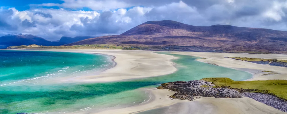
- Luskentyre: a long sandy beach on the west coast of Harris, down a minor road off the A859 between Leverburgh and Tarbert.
- Calanais Standing Stones: a circle of 13 stones with rows leading off it, on a ridge above Loch Roag on the west side of Lewis. They were put up between about 2900 and 2600 BC.
- Butt of Lewis: the northern tip of the island chain and the end of the route, at the lighthouse.
Distance
About 298 km (185 miles) for the cycle route from Vatersay to the Butt of Lewis, by the Visit Outer Hebrides figure. Walk Wheel Cycle Trust (formerly Sustrans) gives 184 miles. The walking route is about 250 km (156 miles) from Vatersay to Stornoway.
If you have a GPX of this route from its official site or a planning app, open it in our free GPX viewer to see the distance, the climb and the height profile. The file stays on your device.
Best time to go
May to September, for the longest days. Cicerone’s walking guide gives April to October as the best period. The weather is changeable in any month and the islands are exposed to Atlantic wind, so allow spare days in case a ferry is cancelled.
Journeys that follow this route
On part of the route or all of it.
- Cycling the Hebridean Way · Simon & Lucy · 160 km of the route
More journeys in Scotland
- Scotland West Coast Train · Greg
- The History of the Sea · saeunn
- Highland Adventure · Nick
- Christmas Ski Trip To Les Arcs · Peter
Flyby films from Scotland
- The Great Escape · saeunn
- Mallaig..and Train Back To Glasgow! · Greg
- THE ATLANTIC · SY
- Mallaig to Fort William · Simon & Lucy
More routes like this
- Land’s End to John o’ Groats by bike · 1,600–1,900 km (990–1,180 miles) · England, Scotland
- Atlantic Coast Route – EuroVelo 1 by bike · about 11,000 km (6,835 miles) · England, France, Ireland, Norway, Portugal, Scotland, Spain, Wales, Northern Ireland
- North Coast 500 by bike · about 830 km (516 miles) · Scotland
- North Sea Cycle Route in Germany (Nordseeküstenradweg) · about 900 km (560 miles) · Germany
- Canal du Midi by bike · about 257 km (160 miles) · France
- Lofoten Islands Cycling Route · about 130 km (81 miles) · Norway