North Coast 500 by bike
- Distance
- about 830 km (516 miles)
- Country
- Scotland
- Difficulty
- Challenging
- Type of trip
- Cycling route
The North Coast 500 is a road-trip route, not a cycle route. It was launched in 2015 to link the far north of the Highlands into one touring loop of 516 miles (830 km), starting and finishing at Inverness Castle. Going clockwise it heads west through Muir of Ord to Applecross, then up the west coast through Gairloch, Ullapool and Scourie to Durness, along the north coast past Thurso to John o’ Groats, and back south down the east coast through Wick, Helmsdale and Dornoch. Cyclists ride it on the same roads as everyone else, and riders have used it as an endurance challenge since it opened.
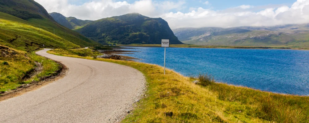
Parts of the route, including the Bealach na Bà, are single-track road with passing places. The route’s popularity brought more traffic, including vehicles driving in convoy, and complaints about drivers who don’t use the passing places, so expect traffic on narrow roads and pull in to let it by. The biggest climb is the Bealach na Bà on the west side, which you can avoid by taking the coast road round the north of the Applecross peninsula from Shieldaig. Plan where you’ll sleep and buy food ahead, as places are spread out on the long empty stretches.
Highlights along the way
- Bealach na Bà: a single-track pass built in 1822 over the Applecross peninsula, climbing from sea level to about 626 m with hairpins and gradients close to 20%. It’s the biggest road climb in the UK, and the sign at the bottom says it’s not advised for learner drivers, very large vehicles or caravans.
- Kylesku Bridge: a curved concrete bridge, opened in 1984, carrying the A894 across the narrows of Loch a’ Chàirn Bhàin between Lochinver and Durness. It replaced the old ferry.
- Smoo Cave: 2 km east of Durness, a sea cave with freshwater passages behind it, where a stream drops 20 m into the cave. Stairs and walkways lead down from the car park.
- Duncansby Head: just past John o’ Groats, the north-east corner of mainland Britain, with a lighthouse from 1924 and the Duncansby Stacks standing off the cliffs to the south.
- Ullapool: the main town on the west coast, on Loch Broom, where CalMac ferries leave for Stornoway on Lewis.
Distance
About 830 km (516 miles) for the official loop from Inverness. Shortcuts and side trips change that a lot.
If you have a GPX of this route from its official site or a planning app, open it in our free GPX viewer to see the distance, the climb and the height profile. The file stays on your device.
Best time to go
May to September, when the days are long this far north. The Bealach na Bà is often closed by snow and ice in winter, so check Highland Council road notices before you go. Check opening dates for campsites and accommodation outside May to September.
More journeys in Scotland
- Scotland West Coast Train · Greg
- Cycling the Hebridean Way · Simon & Lucy
- The History of the Sea · saeunn
- Highland Adventure · Nick
- Christmas Ski Trip To Les Arcs · Peter
Flyby films from Scotland
- The Great Escape · saeunn
- Mallaig..and Train Back To Glasgow! · Greg
- THE ATLANTIC · SY
- Mallaig to Fort William · Simon & Lucy
More routes like this
- Land’s End to John o’ Groats by bike · 1,600–1,900 km (990–1,180 miles) · England, Scotland
- Hebridean Way by bike · about 298 km (185 miles) · Scotland
- Atlantic Coast Route – EuroVelo 1 by bike · about 11,000 km (6,835 miles) · England, France, Ireland, Norway, Portugal, Scotland, Spain, Wales, Northern Ireland
- Shimanami Kaido by bike · about 70 km (43 miles) · Japan
- La Vélo Francette by bike · about 640 km (400 miles) · France
- Altmühltal-Radweg by bike · about 241 km (150 miles) · Germany