Doubtful Sound / Patea by kayak
- Distance
- Varies with your plan. For scale, the fiord runs about 40 km from Deep Cove to the Tasman Sea, Crooked Arm is 14 km long, Hall Arm 8 km and First Arm 6 km.
- Country
- New Zealand
- Difficulty
- Moderate
- Type of trip
- Kayak & canoe
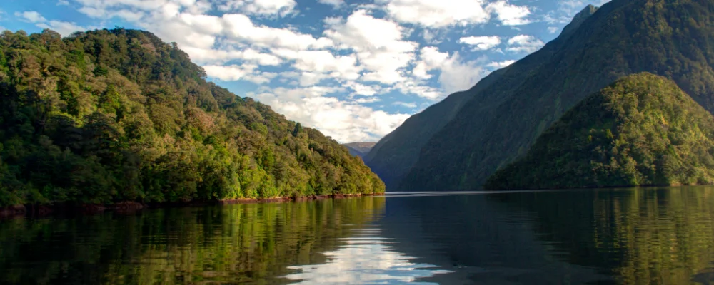
There’s no set kayak route on Doubtful Sound / Patea. It’s a paddling area: a fiord in Fiordland National Park that runs about 40 km from Deep Cove to the Tasman Sea, is up to 421 m deep and has three arms branching off to the south. No public road reaches it. You cross Lake Manapouri by boat from Pearl Harbour in Manapouri to West Arm, then go by coach over the 671 m Wilmot Pass on a gravel road to Deep Cove. Most paddlers go on a guided day or overnight kayak trip from Manapouri that includes that transport. If you want to take your own boat, you have to put your vehicle on the barge across the lake (it usually sails only on Wednesdays) and buy a Department of Conservation (DOC) permit for the Wilmot Pass road.
Fiordland’s weather can change fast. Doubtful Sound gets around 3,000 to 6,000 mm of rain a year, and DOC warns that cold, snow, strong winds and heavy rain can come at any time of year. After heavy rain, hundreds of temporary waterfalls run down the walls. Fresh water from the rain, stained brown by tannins from the forest, sits in a layer 2 to 10 m thick on top of the seawater. The Manapouri power station also lets fresh water out at Deep Cove. Because little light gets through, black coral grows as shallow as 10 m. About 66 bottlenose dolphins live in the sound, and DOC’s rules for boats say to approach slowly from the side and slightly behind, never cut through a group, and not to swim with them when calves are present.
Highlights along the way
- Hall Arm: the 8 km arm that branches off near Deep Cove beside Commander Peak. Browne Falls drops down the slope towards the fiord near Hall Arm, and Helena Falls is at Deep Cove itself.
- Crooked Arm: at 14 km, the longest of the three arms, with First Arm (6 km) further west.
- Elizabeth Island and The Gut: Taipari Roa (Elizabeth Island) Marine Reserve covers 613 ha around the island, and the narrow channel between Bauza and Secretary islands, known as The Gut, is more sheltered than the open water to the west.
- Wildlife: besides the dolphins, the regional tourism body and RealNZ say New Zealand fur seals and tawaki, the Fiordland crested penguin, are regularly seen.
- Getting there: the lake crossing and the drive over Wilmot Pass are part of the trip. There’s no settlement at Deep Cove, only an outdoor education centre, a wharf and a few fishing boats.
Distance
Varies with your plan. For scale, the fiord runs about 40 km from Deep Cove to the Tasman Sea, Crooked Arm is 14 km long, Hall Arm 8 km and First Arm 6 km.
Best time to go
December to February are the warmest months, and guided kayak trips run mainly in the warmer part of the year. Check each operator’s season before you plan. Rain is likely whenever you go. Fiordland’s regional tourism body says June to August is often the most settled weather, but it’s cold, days are short and the Wilmot Pass road can get heavy snow.
More journeys in New Zealand
- Te Araroa · The long walk of Te Waipounamu
- Van Life In New Zealand · Nick
- Bikepacking Through NZ · Kate
Flyby films from New Zealand
- Sunday 15th · The long walk of Te Waipounamu
- Auckland-Santiago-Buenos Aires · Karen
- French Polynesia to Fiji · Adam
- North Island · Nick
More routes like this
- Marlborough Sounds by kayak · New Zealand
- Katherine Gorge by canoe · Australia
- Lower Mekong by boat and bike · Cambodia, Vietnam
- Hudson River by kayak · about 412 km (256 miles) · USA
- Kayaking Lake Powell · USA
- Bowron Lake Canoe Circuit · about 116 km (72 miles) · Canada